Dahlfin II Status

| Last updated: June 26, 2000 |
Dahlfin II Status |
|
|
||
64) 10-16-99, phone call from Oriental, N.C.
Hurricane Irene is coming their way and instead of back-tracking they have managed to get one of the last slips in a marina (Whittaker Creek) and a four-way tie up for the boat. They were thinking of going up a creek but the depth is only 7' and they draw 6'. They had friends who went up a creek and were ok during the hurricane and surge, but afterwards were stranded on their side for week when the water went out again. --pete
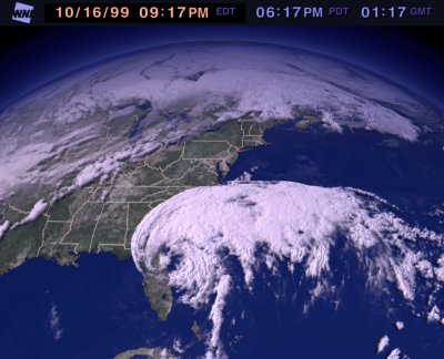
Here are the current pictures (8 pm PST, 10-16-99):
10-18-99 phone call from Oriental, N.C.
The hurricane veered out from the coast a bit. The strongest winds were at 2:30 am and they don't know how high they were but everything held and they weathered it just fine. --pete
65) 10-25-99, email message from Barefoot Landing, SC
10-9-99, 36 21.02 N / 75 56.86 W, Coinjock
At last we are on our way again. Top off the fuel tanks at Coinjock which is supposed to have the cheapest fuel on the waterway but has gone up $0.20/gal just since last June!
10-10-99, 35 40.28 N / 76 05.68 W, Tuckahoe Pt., Alligator River
Mile 103.8. Wind south on the nose, but not too bad for crossing Albemarle Sound. Pipes up afterwards and we slug away to the bottom of the Alligator River. A long day - 47.9 nm.
10-11-99, 35 28.55 N / 76 32.26 W, Slade Creek (Mile 140)
Slade Creek still remains one of our favorites on the ICW. Must be end of crabbing season - no pots. Earlier we had to wind our way through scores of them.
10-12-99, 35 01.40 N / 76 41.93 W, Oriental, N.C. (Mile 181)
Anchored in the harbor. Visited all our old haunts. Been tracking Irene for a number of days now - looks like it's headed this way. Will wait here and see what it's going to do - next stop is Beaufort and the ICW runs right along the ocean - not a good place to be in a storm - besides we have more options to hide here.
10-16-99, 35 01.91 N / 76 40.95 W, Whittaker Creek (Mile 180)
Irene is definitely headed our way. After looking around find most of the creeks are too shallow for our 6'3" draft. One looks possible - South Creek across the Neuse River. But opt for Whittaker Creek which looks fairly secure and exposed only in one direction. We are able to optain one of the LAST slips and move around in the morning. Spend the rest of the day securing the boat. Tie down sails including 2 head sails on rollers (the winds aren't projected as strong as Floyd), take down the bimini, take on water, double up on all lines - 11 total. The slip is very large - for a 50 footer - so we position the boat in the center and use the dinghy to get ashore.
Irene was suppose to get to our area noon Sunday, then in the evening, we really didn't feel much until the middle of the night. Fortunately, the wind came from mainly from one of our protected directions, we don't know how strong it was - the forecast was for 40 - 50 knots for our area. By morning it was all over. Bonnie has decided that she doesn't want to "do hurricanes" anymore.
10-18-99, 34 43.71 N / 76 48.39 W, Spooner Creek, NC (Mile 210.5)
Spend the morning getting the boat back ready for cruising. Head out shortly after lunch to Spooner Creek a new anchorage for us about 8 miles south of Moorhead City. We come in at 1630 on a high tide with some readings of only 4" below the keel! Clearly this anchorage is only available to us at high tide. It's a nice basin surrounded by nice homes and condos. On Tuesday we take the dinghy to a nice dinghy dock in the NW corner, walk across the highway to a Walmart, McDonald's, and Food Lion.
10-20-99, 34 43.07 N / 77 19.44 W, Mile Hammock, NC (Mile 244.5)
We leave in the dark just before 0700 to get out on the last vestiges of early morning high tide. Unfortunately at our next anchorage, Mile Hammock, we need at least 2/3 tide to get in. Which according to our tide finder means we have 7 hours to do 30 miles. So for once we go very slowly, in many places when the wind is right we sail along at 3 - 3.5 K. We shouldn't have worried. Under normal conditions we should have had barely a foot under the keel going in and for the most part had almost 3 feet due to the flooding from the hurricanes. Later in the afternoon are joinned by another 14 boats.
10-21-99, 34 02.95 N / 77 53.36 W, Carolina Beach, NC (Mile 295.2)
Leave at 0700. It's a VERY cold day. A cold front has brought in a strong north wind and rain. The coldest we've been since leaving L. Superior. Fortunately, we are able to sail much of the way. But our timing for the bridges is off adding another 1 1/2 hours to the day. After setting the anchor, turn on the cabin heater (first time in over 3 years) and it works! It helped that Ron serviced it while we were in Chesapeake.
10-22-99, 34 48.12 N / 76 44.66 W, Barefoot Landing, SC
Our longest day so far - 52 nm. Tide is right for the Cape Fear River and we make good time 7-7.5 K. When we get to Barefoot Landing the boats are rafted 4 deep and we take our spot next to a boat - the couple we discovered later cruised L. Superior in '87. A small world. The next day we take a bus to the library and a shopping mall.
10-24-99, 33 36.48 N / 79 05.96 W, Bull Creek, SC (Mile 381.4)
Have now entered the part of the ICW which was closed only a couple of weeks ago due to flooding from the hurricanes - and we can well see why. Large expanses of water - in many areas just the tops of trees showing. In some places they have added secondary markers to help, in other areas there are no markers and we try to find our way by guaging half way between the trees. Lots of current with the tide changes. Anchored in Bull Creek which is a lot wider than before and with a 2+ knot current.
10-25-99, 33 21.82 N / 79 16.93 W, Georgetown, SC (Mile 402.9)
Stopped a couple of miles downstream at Wacca Wache Marina to top off the fuel and water tanks. They told us the waterway was 3 feet above normal - had been 6 feet above. Again have some large open areas of water and have to guess at the water way channel. Lots of current - make good time into Georgetown arriving mid-day as planned to secure a good anchorage close to town adjacent to the bell tower.
Jose has dissapated out in the Atlantic and so far there are no more tropical depressions brewing. Hope this is it for the hurricane season. We are both looking forward to being back in hurricane-free waters again. Trinidad and Venezuela may have been terribly hot - but at least we didn't have to keep looking over our shoulders to see if there were any hurricanes developing or coming our way.
66) 11-8-99, email message from St. Augustine, FL
10-27-99, 33 04.96 N / 79 27.73 W, McCellanville, SC, (Mile 430)
We came in on half a tide (3 1/2 ft) which we clearly need with our draft to get in and out as we had a couple of times with only a few feet under the keel. Tied up to an old dock which rents out a few slips for transients each night (we had called via telephone the (Leland Marine Services - to make sure they would have room for us). This is a quaint shrimping village with lots of shrimp boats and local color. We spent a couple hours walking around enjoying the area.
10-28-99, 32 46.61 N / 79 57.21 W, Charleston, SC, (Mile 469.2)
The area south of McCellanville, where we had seen such shallow water in June was in the process of being dredged - and it was apparent as at low tide we would now have about 9 ft with a couple of 7 ft - so probably should still transit this area at half a tide. Motor sailed most of the day on a nice northerly wind. Set anchor in the "outer" harbor - that is, we didn't go under the 56 ft bridge as usual.
10-29-99, 32 31.90 N / 80 24.64 W, Fenwick Is, (Mile 511.5)
Got to Wappoo Creek Bridge by 0825 only to find it didn't open until 0900. Elliot's Cut is still exciting with its currents. Again, were able to motor sail most of the day. Fenwick Island is still one of the more beautiful wilderness anchorages tucked among the saw grass. Today we passed 4,000 miles since leaving Trinidad in February.
10-30-99, 32 25.19 N / 80 39.39 W, Factory Creek (Mile 539.9)
Waited until 1100 to leave so that we would have at least half a rising tide for the trouble spot at R "184" where we grounded on a low tide in June. Glad we did, as we heard of boats grounding on that spot in the hours while we were waiting. As it was,had good water as we went through (tide 5.8 ft above) with only one 5.9 reading which would have put us on the ground again at low tide. Anchored in Factory Creek just north of the bridge at Beaufort SC because we needed to get a few groceries (no grocery stores in Beaufort walking distance) and the tidal effects are less in this creek.
10-31-99, 32 08.54 N / 80 53.53 W, Cooper River (Mile 586.8)
Leaving Factory Creek had a couple of low readings at entrance green marker. Top off fuel and water at the Town Marina. Go over to the day courtesy dock so we can walk around town and have a breakfast. Leave at 1130.
11-1-99, 32 00.79 N / 81 02.23 W, Herb River (Mile 584.5)
Very interesting thing happened today. We grounded on a sand bar just to the green side of Field's Cut about 1/4 mile before leaving the cut to cross the Savana River. We tried our usual tactics to wiggle off but had almost decided we would have to wait a bit for more water - fortunately the tide was rising. Depth sounder in front of the keel showed 3.5 feet so we had Ron go to the bow to try and bring the bow down and reduce some of the pressure on the keel - a tactic which has worked for us in the past. Just as he went forward, a large ocean going vessel started to pass by the cut and in 30 seconds the boat heeled sharply on the starboard side with the rail in the water - just like you would imagine a grounding and then the tide went out. I couldn't believe that Ron had THIS MUCH EFFECT on the boat - and then saw the ship. Apparently its displacement was so great it sucked out a lot of water from Field's Cut. Then AFTER it passed another strange thing happened: we straightened up, but the stern wake came against our bow and pushed the bow around back towards the red side (where we had been trying to wiggle to with no avail), I gunned the engine and we were off! - without having to wait for the rising tide. We pulled into Herb River just a mile south of Thunderbolt to wait out some very strong projected winds. Didn't think the open saw grass areas which were next would offer much protection for what was forecasted to come. It proved to be a good choice as the trees adjacent to the anchorage provided excellent protection.
11-3-99, 31 38.61 N / 81 11.01 W, Cattle Pen Creek (Mile 625.5)
Low readings in area south of Isle of Hope: we need half a tide to get through. Note: it has really been cold for the last week or so. We use the cabin heater every morning and afternoon when we get in. A few days we've left it running the whole day - a little reprieve to go down and get warm.
11-4-99, 31 21.86 N / 81 19.74 W, South River (Mile 653.7)
Another new anchorage for us in the saw grass. Not as much tidal current as we had expected being so close to an ocean inlet.
11-5-99, 31 02.76 N / 81 25.34 W, Jekyll Island (Mile 684.3)
Get up early so we can be to Jekyll Island by noon. Call ahead to make sure we can get a slip in the marina as at this time of year with the southern emigration it fills up by mid-day. Spend the rest of the day bicycling the island through the forest, wetlands and along the beautiful beaches.
11-6-99, 30 45.93 N / 81 28.31 W, Cumberland Island (Mile 710.9)
Again we get up early to run the short 25 miles to Cumberland Island so we can spend the afternoon enjoying the island. Again we find it quite magical with the live oaks forming an overhead canopy with hanging Spanish moss and the palmettos below filling in the forest. We walk over to the ocean side and walk for miles at the high tide line collecting shells. Then cross over the dunes back into the forest to walk on the Parallel Trail back - it's almost like being in a tropical rain forest.
11-7-99, 30 03.12 N / 81 21.81 W, Pine Island, FL, (Mile 765)
A long day for us - 51.4 nm. At last we are in Florida and its beginning to get a little warmer. We have been to Pine Island twice before and never had any problems. But this time we come in on a dead low tide and ground for a couple of minutes just south of the entrance green marker. Wiggle off and get more low readings until we get into the center of the anchorage - staying well away from the southern shore - and anchor with 4 feet under the keel.
11-8-99, 29 53.46 N / 81 18.46 W, St. Augustine, FL, (Mile 778.3)
A nice short day so we can get into St. Augustine for a lunch at our favorite Columbian restaurant (reminiscent of our South American travels) and walk around this delightful historic city.
67) 11-16-99, pocket email message from Titusville, FL
11-9-99, 29 53.93 N / 81 00.34 W, Daytona Beach FL, (Mile 831.4) About 12 miles south is Mantanza Inlet which always has a lot of shoaling. We time it to arrive just before the peak of high tide which is about 5 ft. Good thing we did because we had a couple of 2.2 readings below the keel, the rest of the passage we had 3-6 ft below the keel. Saw a number of boats grounded today - you really can't stray outside the markers at all in some areas. Anchored just off the ICW behind marker R 40 (enter at R 44).
11-10-99, 28 37.24 N / 80 48.55 W, Titusville FL, (Mile 878) Due to Hurricane Irene, Ponce de Leon Inlet now has shoaled so much that boats drawing 6 feet or more can't pass at low tide. Again we time it to approach just before high tide and have no problems - only one 2 foot reading below the keel. Have had strong northerly winds each day for over a week and have been able to sail each day. On Saturday and Sunday friends drove us down to the SSCA annual meeting in Melbourne. See lots of friends from anchorages past. Highpoint is that we are able to meet and hear Herb from Southbound II at one of the sessions.
68) 1-20-00, pocket email message from Vero Beach, FL
1-11-00, 28 37.24 N / 80 48.55 W, Titusville FL, (Mile 878)
After a hectic visit at home over the holidays visiting friends and family and doing our yearly business chores, we are at last back on the boat in Florida.
1-17-00, 28 37.24 N / 80 48.55 W, Titusville FL, (Mile 878)
Have just spent a week working on the boat and reprovisioning and are now ready to head back south. Weather has been quite cold the last few days with a number of strong fronts passing through with lots of strong winds.
1-18-00, 28 08.74 N / 80 22.37 W, Banana River (The Dragon, Mile 914.1)
Late start filling up water tanks, saying goodbye to friends. Made up for it with a strong W/NW wind and were able to motorsail the whole way at 6.5-7 knots.
1-20-00, 27 39.77 N / 80 22.37 W, Vero Beach (Mile 951.7)
A grey dismal day with north wind. Our first time in Vero Beach and wonder why we haven't stopped before. Take a mooring (no anchoring allowed) $6/night. They have a nice lounge for boaters and all cruising amenities. A free shuttle comes by on the hour to take you to the beach, grocery stores, and shopping centers. Tomorrow we're declaring a lay day to go to the beach and check everything out.
1-22-00, 27 06.89 N / 80 08.62 W, Peck Lake (Mile 992.2)
A beautiful wilderness anchorage just by pulling off to the side outside the marker G 19. Although the guide book says 10 ft to shore, we found some areas of "thin water" and it took us a bit to get a few feet under the keel as other boats were anchored in the deeper water. Can take the dinghy to shore, a short walk over the dunes to the ocean and beautiful sand beach.
1-23-00, 26 50.28 N / 80 03.21 W, Lake Worth (Mile 1014.0)
A short day, but 7 bridges along the way so that made up for it. Take on fuel and water just before reaching Lake Worth. Anchor east of the inner channel as there have been some problems with anchoring permits, inspections, etc. in other areas of the lake. Waiting for weather to cross the stream for the Bahamas. Unfortunately, Herb (Southbound II) SSB has not been very encouraging - the cold fronts are coming across the US, stacked right up against each other with little if any clocking around between. It's also been VERY COLD - we run our cabin heater a lot, but wonder what those poor people on boats without heaters are doing.
NOTE: over the past 3 years we have seen alot of disagreement between our wind speed indicator and others. After daily comparison with other boats in Titusville we now are pretty sure our readings are 5 - 8 knots LESS than others. So at least 5 knots should be added to all the wind speeds we have given over the years.
Well that's it. We may have weather window to cross this weekend, but will wait to see what Herb says this afternoon and tomorrow. The only time we had really rough weather on the trip was when we went thinking we could push the envelope and he said to stay. That was "the night from hell" when we went from Mayaguana to the Caicos and broke the boom. So we are a little gun-shy about not doing what he says.
1-29-00, 26 50.28 N / 80 03.21 W, Lake Worth (Mile 1014.0)
Just a quick note to let you know that we are still in Lake Worth. However, we may have the possibility of a short window on Sunday. Will wait to see what Herb has to say this afternoon. If we do go, we would probably leave about 3-4 am, head for Great Sale Cay, then continue across to the Abacos.
2-2-00
Well we're still here. There is supposed to be some bad weather coming tomorrow and at present it doesn't look to promising after that. Don't know how much longer we're going to hang around and wait. One nice thing is that very good friends of ours who we left from here 3 years ago have come in and now are headed on their way south. So we've been spending a lot of time with them which is lot's of fun. We also have other good cruising friends met on the waterway years ago are coming in a few days.
72) 3-14-00, pocket email message from St. Augustine
3-4-00, 28 08.78 N / 80 36.29 W, The Dragon (Mile 914.1)
Motorsail to the Banana River - wind W/NW. Takes a couple of tries to get the anchor to set.
3-5-00, 28 37.21 N / 80 48.53 W, Titusville (Mile 878)
Wind NW, motorsail close-hauled with the staysail. Rent a car for 2 days and brave the early moring rush hour traffic (scary) into Orlando and visit Universal Studios (neat).
3-9-00, 29 01.53 N / 80 55.16 W, New Smyrna Beach (Mile 846.1)
Tie off at city park dock (free) just opposit west entrance of Sheephead Cut. Lunch at Sea Harvest for the biggest/best grouper sandwiches ever.
3-10-00, 29 14.01 N / 81 01.37 W, Daytona (Mile 829.2)
Timed arrival for Ponce de Leon Inlet at hi tide, but wouldn't have had to. It's been dredged since we were last through to 14 ft - quite a change to less than 6 ft at low tide. Anchored just north of the Seabreeze Highway Bridge.
3-11-00, 29 34.59 N / 81 11.61 W, Palm Coast Marine (Mile 802.8)
Stopped of at Palm Coast so we could reach Mantanza's Shoal at high tide next day. Beautiful swimming pool, jacuzzi and lots of lovely hiking trails through the woods.
3-12-00, 29 51.12 N / 81 18.34 W, 3 miles south of St. Augustine (Mile 781.2)
Palm Coast Marine does not have the advertised 7 ft depth - we had to wait 2 hours for a rising tide to get out. This put us at 2/3 tide at Mantansa's, but we needn't have worried because they have dredged it since we were there in November. The least depth we saw was 11 ft. Anchored 3 miles south of St. Augustine (behind red # 18) so we are in good position to go up the San Sebastian River to haul the boat.
3-13-00, 29 52.68 N / 81 18.88 W, St. Augustine Marine (Mile 779.9)
Today we turned 12,000 miles since leaving Bayfield almost 4 years ago. Went up the San Sebastian River at 2/3 tide, least depth 14 ft. Hauled out promptly at 12:30 - it pays to have reservations and they did a very nice job for us. We couldn't believe how good the bottom looks after more than a year in salt water - last bottom coat put on in Trinadad - Ultrakote. Yet, we are going to put on a couple more coats as long as the boat is out of the water. Took off the Max-prop and started removing the shaft.
73) 3-27-00, pocket email message from Beaufort, SC
3-14-00, 29 52.68 N / 81 18.88 W, St. Augustine Marine (Mile 779.9)
Haul-out. What started out as a good haul-out was short-lived. There were a number of hidden costs including "environmental charges" etc, we had to "tent the boat" for scuffing up the hull for bottom paint (we had decided to add a coat of bottom paint as long as the boat was out of the water) - the contract clearly said tenting only for sandblasting and grinding. We were mislead on the shaft - they had said it would take a week to get it to us, we had a new custom made shaft in hand within 24 hrs. They gouged the bottom paint when moving the pads with the Travel-lift sling. It was obvious that there have been alot of changes since we were there in 1996. We were fortunate that we were able to get our work done quickly (the new shaft - now keyed, coupler and new shaft seals went in just like clock work - of course we had had a little practice in the last few weeks) and we were out of the yard after 5 days.
3-18-00, 30 03.13 N / 81 21.83 W, Pine Island (Mile 765)
Stopped off at Camchee Cove to top off the tanks and went to the beautiful Pine Island anchorage. Had good water both in and out this time.
3-19-00, 30 45.99 N / 81 28.28 W, Cumberland Island (Mile 710)
Really made good time today with the tides and the genny on a strong SE wind. For hours we clipped along at 7-8 knots and even 9+ kts. We had a number of GPS readings of SOG at 9.8 kts! Only once before have we gone faster - surfing down the waves and pegging the knot-meter at 12 kts. The next day we went ashore - this time south to Dungeness. Saw a number of armadillos and horses in the wild - neat.
3-21-00, 31 02.76 N / 81 25.36 W, Jekyll Island (Mile 684.5)
Another favorite stop. We take bikes and bike around the island through the woods and salt marshes. See an alligator up close.
3-23-00, 31 27.51 N / 81 18.24 W, New Tea Kettle River (Mile 646.8) A very cold overcast day and slow going with strong northerly winds. About 2 hours after anchoring in 15 ft of water we were hit by another boat as the tide changed. The owner, who was quite surprised, informed us that he was anchored on 12 ft of chain and 250 ft of nylon rode! We quickly offered to pull anchor and moved FAR AWAY.
3-24-00, 31 49.03 N / 81 08.11 W, Cane Patch Creek (Mile 608.6)
Another beautiful wilderness anchorage anchored amidst the saw grass and a few trees off to the side.
3-25-00, 32 00.87 N / 81 02.33 W, Herb River (Mile 584.2)
A short day, made good time with the tide. Took the dinghy 1.5 miles to the huge Palmer Johnson complex at Thunderbolt. Had lunch ashore, walked around a bit since it had been a couple of days since we had been off the boat.
3-26-00, 32 25.84 N / 80 40.50 W, Beaufort, SC (Mile 563.3)
Made good time with the tides. Surprise - met our friends from South Africa that we had shared Floyd with. Great reunion.
We have had some trouble the last few mornings with really hard starts with the engine. Don't know if it is the starter, fuel pump, injectors etc. Will try and take a closer look at it this afternoon.
74) 4-7-00, pocket email message from
3-28-00, 32 32.04 N / 80 26.79 W, SW Fenwick Island (Mile 513.5)
Left Beaufort around 1100 so we could time getting to the trouble spot at R 184 just before high tide. Sailed most of the way down the broad expanses of the Coosaw River on very strong SW winds. No problems at 184 - but once again it is quite clear we would never get through at low tide. (Note - we just heard from one couple that they hadn't timed the tide right and had to wait 3 hours before they could get through and they draw 1/2 ft less than we do.) Anchor behind one of the few stands of trees in the sawgrass to get some protection from the wind.
3-29-00, 32 45.04 N / 80 00.13 W, Stono River (Mile 472.6)
Leave at 0900 so we reach another shoal area (R 110 North Edisto R) with at least half a tide. Unfortunately, this makes us 15 min too late to make th 1600 opening of the Wapoo Creek bridge in Fields cut. Rather than wait for the next opening (1830), we anchor just south of the cut.
3-30-00, 32 46.55 N / 79 57.20 W, Charleston, SC (Mile 469.2)
Get to Wapoo Ck Bridge shortly before 0900 - its first opening. Anchor off the marinas and spend the day walking the beautiful historic district looking at beautiful mansions and the magnificent spring gardens. End up riding the trollys around town.
3-31-00, 33 02.05 N / 79 32.50 W, Awendon Creek (Mile 435.7)
A long slow day against wind & tide. Once again we are thankful for our staysail as we are able to get another 1.5 to 2 K. Anchored in the wide open sawgrass - lots of waterfowl.
4-1-00, 33 21.87 N / 79 16.99 W, Georgetown, SC (Mile 402.9)
Slow at first, then the tide changes. Anchor adjacent to the picturesque clock tower. Spend the next few days doing laundry, getting a propane tank filled, walking out for a Walmart fix, getting groceries, eating the BEST shrimp creole and waiting for mail which never comes.
4-5-00, 33 36.19 N / 79 05.88 W, Bull Creek (Mile 381.4)
A cold day on the back side of a cold front - glad we have the cabin heater. Top off the tanks at Wacca Wache and anchor amongst the cypress still one of the most beautiful anchorages on the ICW.
4-6-00, 33 48.08 N / 78 44.72 W, Barefoot Landing (Mile 353.5)
Still one of the more popular spots on the ICW with all of its neat shops and restaurants. However, there are rumors they are going to begin charging and it will no longer be free. We are amazed at the number of boats heading north - we thought we would be the only ones going this early.
We've had better luck starting the engine by turning on the key and letting the fuel pump run 10-15 seconds before pushing the start button. It's only in the cold mornings that we've had any problems. Subsequent starts during the day have been fine. If it is the fuel pump going, we do have a spare.
75) 4-20-00, pocket email message from Fort Monroe
4-8-00, 33 55.07 N / 78 01.49 W, Southport, NC (Mile 309)
Another cold front is coming with gale force winds, 30-35 knots. Our intentions were to anchor in the Southport basin but a large sailboat with a huge amount of nylon out was anchored right in the middle and it didn't look like there would be much room for us when the wind switched. So we tied up to the end of the old dock reserved for transients which the guide says has 4 ft at low tide - clearly it has been dredged because we never had less than 3 ft under the keel. It really blew during the night - but we don't think it was 30 knots.
4-10-00, 34 12.92 N / 77 48.93 W, Wrightsville Beach (Mile 283.1)
Waited a day for the wind to switch around from the north so the seas wouldn't stack up in the Cape Fear River on the tide. Ran the river on a flooding tide (sure would hate to run it against the tide), but then had the tide against us in for a few miles in Snows Cut.
4-11-00, 34 19.47 N / 77 19.47 W, Mile Hammock (Mile 244.5)
Left at 0600 so we could get into Mile Hammock close to a high tide. Note - the Wrightsville Beach Bridge will open on demand if it is before 0700 instead of only on the hour.
4-12-00, 35 01.42 N / 76 41.85 W, Oriental, NC (Mile 181.0)
Again left at 0600 so we could get out on 2/3 of a tide. Went straight to Oriental because another front is coming in. The fronts have been coming in every 4 - 5 days with really strong winds and lots of rain.
4-15-00, 35 40.30 N / 76 05.58 W, Tuckahoe Pt. (Mile 103.8)
A really miserable day with strong winds aft of the beam and lots and lots of rain. We later heard that tornados had been sighted in Oriental County and Moorhead City to the south of us. Had planned on staying at an anchorage south of the Pungo Canal, but when we got there conditions were so bad and visability so poor we didn't think it prudent to try and go in. So we went the extra 20 miles through the canal making it a really long day for us - 68 nm or 78 StM.
4-16-00, 36 20.96 N / 76 56.89 W, Coinjock (Mile 49.5)
The calm after the storm. Had an easy crossing of Albemarle Sound. However, had really dense fog for most of the Alligator River - the Lake Superior variety. Had to run the markers on radar and GPS.
4-19-00, 36 43.25 N / 76 14.29 W, Great Bridge (Mile 12.2)
Again had fog on Curituck Sound but not quite as bad as yesterday. Tied up to the old free dock north of the bridge. Have been having some hard starts with the engine in the mornings, so Ron put in a glow plug and changed all 3 injectors. According to the manual they should be flow checked every 700 hours (which no one does) and the last time we change injectors was in Venezuela. The weather is really bad out on Chesapeake Bay as another front passes through - so we decided to stay put.
4-20-00, 37 00.36 N / 76 18.93 W, Fort Monroe
Today we passed mile marker 1 as we passed through Norfolk. After transversing 1000 miles of the waterway, by paying paying close attention attention to the tides, we never grounded or touched bottom once when we moved over to let another boat pass by. The weather is really bad as another front approaches. There seems to be less and less time between the fronts.
Well that's it. As you can see, we have really been having lousy weather the last couple of weeks. We had hoped to get to church for Easter, but now it looks like we might not. Fort Monroe is a military base and we could possibly be stuck here a few days. They really don't encourage going ashore and we would have to walk off the base to find a church.
5-2-00, Sassafras River
Just a quick note to let you know that we are at the top of the Chesapeake presently entering the Sassafras R. We will leave the Chesapeake tomorrow via the C&D canal heading for Cape May, New York and then the Erie Canal. Will send you more updates hopefully when we reach Atlantic City. We found out that they were not as strict on the military base as we had been told. So we got up at 0530 Easter morning and went ashore for a military sunrise service on the base in a park overlooking Hampton Roads. They had a community chorus and the military band - it was all very impressive. Afterwards had an Easter buffet breakfast in the famous Chamberlain Hotel.
76) 4-20-00, pocket email message from Statten Island
4-24-00, 37 41.49 N / 76 21.27 W, Pitmans Cove Indian Creek
Looks like we have a 1 day window before another front moves in. Tuck way up the creek around the bend and are in a mill pond with perfect protection from the NE wind. It blows hard from the north for 2 days - 30 K out in the bay. For the next 2 days we dinghy ashore to the adjacent dock and hike 2 1/2 miles into the town of Kilmarnock for lunch. When ashore, we are able to see another boat anchored in the outer part of the creek which doesn't do as well and is really being tossed around.
4-27-00, 38 19.82 N / 76 27.08 W, Mill Creek, Solomons
A cold rainy day with a strong southerly wind. Our plastic side curtains, which we had intended for use only at anchor, work nicely under sail and greatly improve the creature comforts of the day. We also keep the cabin heater running all day.
4-28-00, 38 58.51 N / 76 28.98 W, Annapolis
Would have liked to spend more time in the Solomons, but feel we have to take advantage of the weather before another front with strong northerly winds moves in. Four packages waiting for us at the Harbor Masters office - 2 mail - one of which has been chasing us up and down the East Coast for the past 2 months. Visit our favorite restaurants, again take the local bus into a suburb of Baltimore.
5-2-00, 39 22.30 N / 75 56.12 W, Sassafras River
Once again the side curtains help on a rainy day. Motor sail on a light NW wind.
5-3-00, Cohansey River, Delaware Bay
We leave the top of the Chesapeake via the C&D canal. Make such good time with the tides in the canal that we decide to keep going. Hit an ebb tide just right for sailing down the Delaware River and clip along at 7 k. Enter the Cohansey River at low tide and find out the hard way that there is a bar on the starboard side (when going in) of the channel past the green marker. Took a little over an hour for the incoming tide to lift us off so we could proceed in. Thursday: waiting for weather. Blowing like crazy from the SE - by mid-day lots boats are giving up the run down to Cape May and coming in for refuge with lots of stories how rough it was out there.
5-5-00, 38 37.01 N / 74 53.31 W, Cape May
A fisherman and his wife come by in the morning after pulling nets in an open boat to see if we are alright since they had seen us sitting here for a couple of mornings. Nice. We chat a bit and they give us a couple of Weak fish - double nice. We leave at 1100 on a high tide, but by favoring the north shore up to the marker and then slipping just south of the marker to get out, were able to carry 20-22 ft (6 ft tide). After a couple of hours are able to catch the ebbing tide and have a quick run down the bay. Enter Cape May Canal at low tide and have a couple of skinny spots between the bridges & ferry landing. Anchor off the coast guard station in 15 ft.
5-6-00, 39 22.58 N / 74 25.42 W, Atlantic City
Would liked to have laid over in Cape May, but have a good 2 day weather window for going up the coast, so decide to take it. End up motoring sailing most of the way. Take on fuel and dock at the Trump Marina ($2/ft).
We are presently at Staten Island in New York Harbor. We had an uneventful 2 days coming up the coast with good settled weather. The run from Atlantic City to Sandy Hook you are especially vulnerable because it is 84 nm and there is NO PLACE where you can get off the ocean for refuge should bad weather come up. Tomorrow we are taking the train to the other end of the island to the Staten Island Ferry and across to the Battery on Manhatten. Will visit the US Trade Center complex, maritime museum etc. Should be lots of fun. Then we will enter the Hudson River and go north to Catskill where we take down the mast for transitting the Erie Canal.
77) 4-20-00, pocket email message from Statten Island
5-6-00, 40 26.71 N / 73 59.86 W, Sandy Hook - New York Harbor
Left Atlantic City at 0330. Motorsailed up the coast on light southerly winds. Set anchor shortly after 1800.
5-8-00, 40 32.21 N / 74 07.97 W, Great Kills Harbor - Staten Island
No transient moorings available, a fellow offered us the use of his. The next day took the train to the Staten Island Ferry and then across to the Battery on lower Manhattan. Visited the World Trade Towers, lunch in the Winter Garden, then the viewing lobbies at the Mercantile Exchange (wild), Wall Street and the viewing lobby for the Stock Exchange, and the South Street Seaport.
5-11-00, 41 07.56 N / 73 54.24 W, Hook Mt. Hudsen River
Sailed across New York Harbor and into the Hudsen on strong westerly winds. Photos of the Statue of Liberty, Ellis Island and lower Manhattan as we sailed by. Anchored beneath beautiful bluffs strangely reminiscent of Otter Head on Superior's East Shore.
5-12-00, 41 26.52 N / 73 59.67 W, East of Cornwall on the Hudsen
Sailed by West Point and took the appropriate photos. This canyon area is one of the most beautiful on the Hudsen. It is difficult to find anchorages on the Hudsen because it is either very deep (in excess of 60 ft) or very shallow (less than 5 ft). So we felt lucky to find this beautiful anchorage with 22 ft.
5-13-00, 42 12.66 N / 73 51.41 W, Riverview Marine - Catskill
Begin the task of taking down the mast. With all of our additional gear, it's quite an operation.
78) 6-2-00, pocket email message from North Tonawanda
5-17-00, 42 22.16 N / 73 47.79 W, Coxsackie Island
A nice anchorage for a late start from Catskill.
5-18-00, 42 28.50 N / 73 47.35 W, Coeymans on the Hudsen
The Erie Canal has been closed for a week and boats are stacking up at the entrance, so we decide to wait a little further downstream.
5-20-00, 42 47.22 N / 73 40.76 W, Waterford
The locks re-opened today so we move up to take the place of those who left.
5-21-00, 42 49.29 N / 73 58.72 W, Isle of Oneidas
Went through the first flight (2-6) and Lock 7. Found a nice anchorage behind the Isle of Oneidas. A lot of people don't like anchoring with the mast down. We don't see any difference.
5-22-00, 42 57.01 N / 74 22.33 W, Terminal Wall, Fonda
LOTS of debris in the water: tires, huge logs, even whole trees with complete root systems. Stop at Lock 11 for lunch and to make a few phone calls.
5-23-00, 43 02.06 N / 74 51.96 W, Little Falls
Locks 23 - 26 are closed because of more flooding. Boats are stacking up on either side of Lake Oneida. So we decide to wait.
5-25-00, 43 12.52 N / 75 37.28 W, Lock Wall 21
They are taking 2 tugboat guided flotillas up to Oswego, so we decide to move on and take advantage of the vacated spaces.
5-26-00, 43 14.45 N / 76 08.31 W, Brewerton
Locks 23 - 26 remain closed to westbound traffic. Boats begain to stack up again.
5-30-00, 43 04.23 N / 76 33.43 W, Terminal Wall at Bridge E-83
At last they open up 23 - 26 and we are told we can go, but only "at our own risk". Water is high, but nowhere any of the debris we saw in the eastern end.
5-31-00, 43 05.52 N / 77 05.58 W, Newark
6-1-00, 43 05.52 N / 77 30.84 W, Pittsford
6-2-00, 43 01.84 N / 78 52.95 W, North Tonawanda
Up at 0530. A long day - 75.1 nm . But we make really fast passage with the locks (4) and all the opening bridges (15) so that we hardly have to wait. We are now making ready to re-step the mast and enter Lake Erie.