Dahlfin II Status

| Last updated: March 5, 2000 |
Dahlfin II Status |
|
|
||
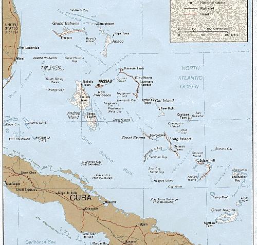
16) Fax from Nassau, 1-30-97:
Arrived in Nassau yesterday.
Crossed Gulf Stream 1 day later than I told you on last message - wind piped up quite a bit just before we were intending to cross. Actually it was a good thing we waited that extra day. Finally left at 1am Thursday 23rd of January. Beautiful crossing- no wind, flat sea, full moon, fast crossing - we got a bit of a kick from the stream. Went all the way into Lucaya on Grand Bahama Island - 83 nm. Checked into customs and immigration - "no problem" as they say in the islands. Two lay-over days in Lucaya - we are at a fancy marina resort complete with an Olympic swimming pool, hot tub, etc. Had our first conch - we love cracked conch and grouper, it is absolutely delicious.
1-23-97, 26 30.84 N / 78 38.68 W Lucaya, Great Bahama Island
1-26-97, 25 47.07 N / 77.54.01 W Great Stirrup Cay, Berry Islands
1-27-97, 25 40.02 N / 77.45.52 W Market Fish Cays, Berry Islands
Nice sail but when went to turn on engine we had water in the engine AGAIN! In spite of the check-valve put into the line in Lake Huron. This time conditions were in our favor. Had to sail into anchorage and set anchor under sail - "no problem". Went very nicely. Worked on engine, got all the water out (this time salt-water) and had it running early the next day. Needless to say Ron is working on the problem so it won't happen again - twice is enough!
1-28-97, 25 32.92 N / 77.42.93 W Frozen Cay, Berry Islands
Did our first snorkeling in a little lagoon. Ok - but not the real thing. Looking forward to coral, trying out our new wet suits and pole spears for getting our own grouper, conch, and lobster!
1-29-97, 25 04.52 N / 77.19.11 W Nassau
After motoring to Lucaya we have had lots of GREAT SAILING. Good constant winds 14-17 knots, NE, E, and SE.
When we leave Nassau will be heading to the Exumas - should be getting into Georgetown around mid-March where I believe the next phone is.
- Bonnie and Ron
17) Phone call from Nassau, 1-31-97:
Hauled the boat in Nassau to re-pitch the Max-Prop. Dad wasn't happy with
the power he was getting.
More on the water in the engine incident: Dad thinks the riser in the
exhaust is too low and so he is raising it 8". They put in a new Yanmar in the
spring of 1996 and it is lower profile than the old engine. The combination of
the lower engine and the boat sitting low in the water is probably the cause.
Dad is installing another check-valve after the water-lift muffler. After that
they will have two check-valves. The current one is right at the transom. Dad
is also raising the vent hose that breaks the anti-siphon loop way up inside
the cockpit coaming. This should help avoid siphoning water in also.
They were expecting a mail-drop in Nassau but it was mailed two weeks ago
and did not arrive. It will be forwarded to Georgetown when they will try and
get another also in mid-February.
Most islands in the Exumas are uninhabited so they are excited to move on.
Exumas:
18)Fax from Warderick Wells in the Exuma Land and Sea Park, 2-7-97:
After getting our repair part manufactured (an extension to raise the exhaust loop on engine) and all our business taken care of we departed Nassau Saturday afternoon and went to Rose Island. Rose Island is a few miles east of Nassau and has a lovely anchorage which is nice and quiet. Saturday crossed the Yellow Banks to Allens Cay in the Exumas. Interesting sailing in 15 feet of water (wind NE 10-15 knots) sprinkled with coral heads - but you can really see them as they are quite dark and easy to dodge. Allens is noted for large iguanas (2-3 feet) and we got some great photos. Monday we went down to Highbourn Cay where they are building a marina (quite an undertaking in the wilderness) have a fax and a small grocery store. Anchored on the west side (wind E 10-15 knots) and did our first snorkeling on a small coral reef. Neat! Beautiful colors and beautiful fish. We are glad we had our wet-suits as the water was on the chilly side and we were in a fair bit of time. Today we are going to head down to Shroud Cay, wind E 15-20 knots.
2-1-97, 25 05.19 N / 77 14.22 W Rose Island
2-2-97, 24 44.86 N / 76 50.29 W Allens Cay
2-3-97, 24 42.87 N / 76 49.78 W Highbourn Cay
The repair for preventing water from getting into engine is still in progress but here is the plan:
Hopefully this will work. We have all the parts and are just looking for a lay-over day when we aren't snorkeling etc. to do the job but will tackle it in the next few days.
We are finally out of range of Minnesota Public Radio and Ron is going through Garrison Keillor (Prairie Home Companion) withdrawal pains. So if you ever get a chance to tape the show he sure would appreciate a tape or two.
Friday Feb 7, 1997. We are presently at Park Headquarters - Warderick Wells in the Exuma Land and Sea Park. They have a fax so we can send this.
2-4-97, 24 32.03 N / 76 47.88 W Shroud Cay, wind E 15 knots. Hiked to a well on the island that has been in use by sailors for over a century. NEAT! The whole central part of island is man-grove swamp laced by intricate streams and canals. Similar to the Bustard Islands (Lake Huron) and interesting dingy exploring.
2-5-97, 24 27.95 N / 76 46.16 W Hawksbill Cay, wind E 10-15 knots. In the morning we took streams via the dingy to east side of Shroud for a magnificent view of Exuma Sound with the seas rolling in on the beaches. Then went atop a knoll to "Camp Drift-wood" where sailors have brought up all sorts of drift-wood and flotsam over the years - you would have to see it to believe it - even a telephone. We took up our token piece marked with our name. Pulled anchor around noon and went a few miles down to Hawksbill which is one of the more beautiful islands in the Bahamas. Hawksbills has lots of vegetation and palms whereas most of the Exumas are quite scrubby - almost barren with the real beauty below the water. I dove on a few coral heads in the anchorage while Ron completed #1 on the engine project list.
2-6-97, 24 23.79 N / 76 37.93 W Hawksbill Cay, wind E/SE 15 knots. In the morning climbed the peak with large stone cairn on Hawksbill overlooking the anchorage - beautiful picture postcard photos. Then walked a couple miles on a beautiful sand beach. Pulled anchor just before noon and went down to Warderick Wells. Arrived mid-afternoon and picked up our mooring number reserved by VHF the day before. This is a pretty laid-back and under-staffed operation (only warden, his wife, and 2 month old baby) as compared to Isle Royale (Lake Superior). Lots of nice trails on the island, some good diving on coral heads in the area - and get this: Happy Hour at 4 pm at the headquarters veranda on Saturday. We can't exactly see Isle Royale doing that. Everyone brings something to munch on and their own drinks. We are going to stay here a few days to finish up the engine, do a little hiking, some serious snorkeling, and make a real effort to slow down and get on island time.
It's a small world. Some of the sailors back home might be interested to know we've met a few out here from home. Last Thursday had lunch with Tom Lux in Nassau. Met the family on Nate The Great from Duluth on Nassau. Met folks on Rainbow's End (friends of Massey's) in Titusville before we left. Yesterday met friends of Larry Carpenter and Judy Taylor: Dave, wife, daughter - we met them a couple of summers ago at Stockton Island watching a big black bear on the beach with Larry and Judy.
That's all for now, Bonnie and Ron Dahl
19) Fax from Spanish Wells, 2-13-97:
Once again, I didn't think I'd be writing so soon, but we are at Spanish Wells where they have a BATELCO tower (Bahamas Telephone Co.) where we can send a fax for just $1/page! It costs 55 cents to send a letter which goes out on a slow "weekly" (monthly?) mail boat and even though they have a telephone tower, they don't have a machine that will take my $1/min debit card so I would have to use my regular telephone card at over $2/min. So I just can't miss taking advantage of this inexpensive way to contact you. By the way, this is pretty good information in itself and we're finding that fax is THE way to communicate. When we get to a spot where we'll stay, maybe I'll try sending you a fax number and you can try writing back.
2-9-97, 24 18.15 N / 76 32.32 W Cambridge Cay, wind < 5 knots E. Left Warderick Wells and went on the outside (sound side) down to Cambridge. Went snorkeling to the "Sea Aquarium" (still in the park) and saw beautiful fish and coral. Then tried snorkeling Plane's Reef - complete with a small sunken airplane. We didn't realize the current was so strong, Ron had gone further down the reef and got tired trying to make it back. I didn't have so far and got to the dingy. I tried to pull anchor to go and get him but it was wedged in coral so I removed the dingy seat to buoy/mark the anchor line and then get him. It took a fair bit to the anchor loose. The learning curve is straight up and we are a lot more discerning now on gauging currents/snorkeling, etc.
2-10-97, 24 16.42 N / 76 32.34 W Chicken (Fowl) Cay, wind 10 knots E. Again on the outside just a few miles down to a really neat anchorage. Went snorkeling in the caves at Rocky Dundas (just like the caves at Devil's Island in Lake Superior), only really beautiful with lots of coral just outside and beautiful fish. Then we went and snorkeled on a 1/2 miles long reef in Conch Cut, this time using the current to our advantage, tying the dingy on our weight belts and drifting down current. (By the way, those weight belts you gave us so many years ago work perfectly and are absolutely necessary to counter the flotation of our wet suits.) Chicken Cay is just outside the part and we were finally able to get our first conch; Ron waited patiently in the dingy while I dove on sand and grass and got 3 nice conch in about 45 minutes. We had a dickens of a time getting those little "hummers" out of the shell. Cleaning them is a bit messy and skinning them is the pits and quite time consuming. I pounded them like crazy and lightly fried them in bread crumbs with seasoning and they were absolutely delicious along with "peas 'n' rice" - a regular island dinner. During the night the wind switched to the north (a light, somewhat dissipated "norther" coming through) and at about 5:30 am had about 1/2 hour of the keel rubbing on the sand at low tide.
2-11-97, 24 11.21 N / 76 28.44 W Big Majors Spot (just north of Staniel Cay). Sailed down the "inside" (banks side), wind was N at 15 knots. Stopped off at Samson Cay for water and fuel. First time we paid for water, 45 cents per gallon. We are reluctant to start the water maker because once started we will have to keep it up every few days and would like to wait until we are clear of Georgetown before beginning. Anchored on west side of Big Majors. On Wednesday dingied over to the Staniel Cay, a really neat little town. Three grocery stores: Island General Store, the Pink Store, and the Blue store. Yes, the buildings are really pink and blue and they paint their buildings in all sorts of bright colors. Had lunch (conch burgers) at the Happy Peoples Marina. Walked up to the Thunderball Club. Later today we will snorkel in the Thunderball Cave where the James Bond movie was made.
Single Side Band: is an absolute must for cruising off-shore. Essential for getting the weather and great to talk with other boaters out of VHF range. So a receiver is not enough, it is pretty important to be able to transmit too. I've talked to lots of boats we've met along the way, sometimes hundreds of miles away. I get up every morning at 6:30 am and start listening to the weather nets (it literally plans out day for us) and I can't tell you the information we are getting by listening to those who are a hundred miles or so ahead of us and taking the same track we will be on.
The engine repair for keeping water out of the engine is at last complete and Ron feels confident we won't get water in it again. I'm still a little gun shy, and of course we need some good seas and apparently good heel to starboard to check it out.
We still didn't get the pitch correct on the max-prop and are looking for a spot to haul the boat again, possibly at Long Island after we leave Georgetown.
Love to everyone, Bonnie and Ron
20) Fax from Georgetown, 2-26-97: At last we have arrived in Georgetown. Thought I would write this now, giving you all the up-to-date information.
2-16-97, 24 06.01 N / 76 24.21 W Black Point, Exumas. Went to an interesting local restaurant with some friends, had lobster and grouper.
2-17-97, 24 02.05 N / 76 22.39 W White Point, Guana Cay. Weathered strong winds, excellent protection.
2-19-97, 23 54.12 N / 76 16.25 W Cave Cay, Exumas. Interesting sailing in 20 knots of wind at 6.5 knots with only 2 feet of water under the keel. As we re-entered the islands from the banks finally had to reconcile with our now 6 foot draft. At one point we had only 6 inches under the keel as we motored over the sand. No problem - we had a rising tide and in this section of the Exumas have learned to pay close attention to the tides. Good snorkeling off the NW shore of Cave Cay.
2-21-97, 23 53.65 N / 76 15.99 W Musha Cay, Exumas. Lots of sand dollars on banks south of Musha Cay. Had a 5 hour Mexican dominos marathon on another boat with 8 people from other boats. Absolutely hilarious.
2-23-97, 23 31.68 N / 75 46.11 W Georgetown.
We arrived in Georgetown on Sunday after waiting for 4 days to go on "the outside" into the deep waters (how nice to be sailing "off soundings" for a change) of Exuma Sound, the last 35 miles to Georgetown. The winds have been pretty strong, 20-25 knots right on the nose. Although we have sailed in strong winds like this often, the problem is getting in and out of the cuts between the reefs. Going out through the cuts into the sound from anchorages and then most importantly coming in through the reefs to get into Georgetown. It is just about impossible to do it when the wind is 20+ out of the east. Some people were "weathered in" for over a week, we were fortunate that we were in spots where we were able to move down on the inside and only had to wait 4 days. During that time we were able to do some snorkeling on coral heads, in caves, and underwater caverns around some of the edges of the islands - much like the caves as Devil's Island (Lake Superior). Underwater the coral and brightly colored fish are unbelievable - I don't think I will ever tire of it. Unfortunately we still haven't been able to spear any lobster - in fact we haven't seen any except in Exuma Park where they are protected. We have gotten conch - fun to dive for - the dickens to get out of the shell and clean. They are delicious when lightly battered and fried. Also, during our "waiting for weather" we made lots of really good friends on other boats for potluck dinners.
In Georgetown there are about 350 boats here, the town has about 800 permanent residents. Although the town is very small, there is a grocery store, some local produce markets, straw markets, a couple of dive shops, outdoor food vendors, a "bakery" that comes in and operates in a small bus/van, some neat restaurants: The Two Turtles, Peace and Plenty. It is a place to meet other cruising folk, yesterday was our first day "in town" and we couldn't believe how many folks we already knew. Everywhere we bumped into someone and talked for hours on the street. Georgetown is also very social. Every morning there is a cruisers net that goes out on the radio announcing events of the day. For example, every Monday and Wednesday morning aerobics on Volleyball Beach, tomorrow at 1:00 a Women's Cruising Seminar on Hamburger Beach, hikes starting on Sand Dollar Beach, tonight a barbecue on the Two Turtle terrace, and of course daily volleyball games. There are organized pot-luck dinners and they even have a Ladies Cruising Choir. The culmination of all this is Regatta Week which begins in early March with lots of sailboat races, games, organized activities, and of course volleyball tournaments. Already people are signing up, practicing, going over the rules, etc. They expect another 100 boats coming in for this. Lake Superior was never like this!
Unfortunately Georgetown is located on Elizabeth Harbor which is very large: about 10 miles long and 2 miles wide. We are presently anchored at Hamburger Beach and it is 2 miles across into town. The wind is always blowing 15-20 knots so it is a very rough and wet dingy ride across. Yesterday was our first day into town - we wore bathing suits across (some folks made the trip in foul weather gear) and then changed into dry clothes.
Although Georgetown is a place to relax and get together, for us it is the last place to re-provision and get ready for what will probably be the toughest part of the trip: heading east into the Out Islands against the strong prevailing winds. The further south we get the incessant trade winds will be right on the nose. We've been listening on the Single Side Band to boats that are ahead of us. In many cases they are waiting two weeks or more in spots just for the weather window when the winds lay down a bit to make travel against them reasonable. I know it will be tough and I hope we have what it takes. I have no idea if it will take one month or two to make the Virgin Islands.
We will cut this short now and go into town and get it sent.
69) 2-7-00, pocket email message from Green Turtle Cay
2-3-00, 26 50.28 N / 80 03.21 W, Lake Worth (Mile 1014.0)
After 10 days of waiting for weather, we finally got a good window for winds but marginal for unsettled conditions and took it. Topped off the tanks with fuel and water and cleared Lake Worth Inlet at 1030. Steered E/SE for about 11 miles to get a better angle on the stream and then rode the stream most of the way to north of Memory Rock sometimes going 8 and 8 1/2 knots. At times the crossing was a little rough as we experienced rain squalls (4) and 1 thunderstorm during which we had seas going every which way. But it was short-lived and other than that had favorable winds and seas which is the most important part. Entered the banks 10 miles north of Memory Rock at 19:30. Had a nice sail across the banks on a southerly wind through the night.
2-4-00, 26 58.82 N / 78 13.09 W, Great Sale Cay
Came into Great Sale on radar and waypoint (Explorer charts) at 05:00. Set anchor with barely 2 ft under the keel and went to bed. 111.2 nm. Note: according to Herb that was the last window for at least the next 5 or 6 days.
2-5-00, 26 59.39 N / 77 41.29 W, Allans-Pensacola W.
Had a beautiful sail across the top of Great and Little Sail on a 10 k (our reading - probably was more) northerly wind. Set anchor at low tide with 5 inches under the keel. Guess we are going to have to get used to that with our deep draft. 38.4 nm.
2-7-00, 26 45.50 N / 77 20.16 W, Green Turtle Cay
Anchored on the outside of the Government Dock and went ashore to check into customs and immigration. Note: the fees have gone up since we were here last - a straight $100. Not all that bad when it includes everything - even a fishing license for the duration.
70) 2-17-00, pocket email message from Marsh Harbour
2-8-00, 26 49.26 N / 77 22.07 W, Manjack Cay
A beautiful sunny day with no wind, so motored 5 miles north to Manjack Cay. Spent the afternoon wandering trails ashore in some kind of a beginning development. Also did lots of walking on the beaches on the outer islands facing the Atlantic.
2-9-00, 26 46.68 N / 77 20.15 W, White Sound, Green Turtle
A front is forecast to come through with very high winds and Manjack is quite exposed, so we pull anchor and head to White Sound which is an all weather harbor. We go in on a rising almost full tide, at times with a little less than 2 ft below the keel. During the night, the wind really pipes up, 25 k. Next day walk around the island into town (3 miles one way) for lunch.
2-11-00, 26 41.27 N / 77 09.37 W, Baker's Bay
With the strong winds a 'rage' has been building around Whale Cay passage, but finally got a 'go' today with calm winds. Still was a little rolly with swells on the ocean side. Saturday did a lot of beach combing and exploring the area which was once the site for a cruise ship drop-off.
2-13-00, 26 32.87 N / 77 09.37 W, Marsh Harbour
Have had absolutely no wind the last 2 days. Sea of Abaco is like glass. Get into Marsh Harbour just before high tide and have a hard time finding a spot where we won't be aground at low tide. Apparently there is lots of silting in from the hurricanes.
2-15-00, Conch Inn Marina
While pulling anchor at Baker's Bay the shaft spun out of the coupling (the set screw in the coupler sheared - we believe from just general wear) stopping with the prop hitting the rudder. While Ron worked to get at the coupler, Bonnie dove on the shaft (took 4 tries) to push it back in. In order to get to the coupler, we had to transfer 20 gal diesel from the main tank to another tank so we could move the main tank. Ron made the repair by hand-drilling into the shaft about 3/16 inch to receive another bolt/set screw. We couldn't use the inverter with the engine on because the exhaust hose was disconnected. Because we were not sure how this repair would hold up under the rigors of heavy going, we went into the marina where we would have electricity and Ron installed a 3 inch 5/16 inch bolt through the coupler and shaft. We originaly had a hose clamp on the shaft to keep it from backing out - it didn't hold - we now have a zinc on to hold it in place. This shaft has no keyway and we will be replacing it with one that does when we get back to Florida.
2-19-00, 26 35.72 N / 77 00.47 W, Man O' War Cay
Went all of 6 miles over to Man O' War - the repair seems to be holding. We were lucky to find a mooring as boats are coming from all around for a big fund raiser (food, music, flea market) for the school. It's great fun and we meet lots of friends from anchorages past.
2-20-00, 26 32.29 N / 76 57.55 W, Hopetown
Once again we are very lucky to get a mooring in this small harbor as there is no room for anchoring on the inside. Note: with both Man O' War and Hopetown we came in/out on a rising high tide and had no problems, but would clearly have been aground on low tide. Hopetown is absolutely delightful - one of the nicest spots we've been to in the Abacos.
71) 2-29-00, pocket email message from Vero Beach, Florida
2-25-00, 26 39.99 N / 77 07.14 W, Delia Bay, Great Guana
Left Hopetown about 1 hour before high tide and had less water than coming in - a couple of spots just a little more than a foot under the keel. Great sail to Delia Bay in the lee of the islands - wind E 15 knots. Hiked across to the famous Nippers on the ocean side for lunch.
2-26-00, 26 54.14 N / 77 28.95 W, Powell Cay
Another great sail - wind E 15 k.
2-27-00, 26 58.75 N / 78 12.88 W, Great Sale Cay
Looks like we have a great window for crossing the stream, so we start making tracks. Good downwind sail to Great Sale (48 nm). Set anchor and get a couple of hours of rest. Pull anchor at 1800 and motor sail over the banks through the night.
2-28-00, 27 28.08 N / 80 22.28 W, Ft. Pierce, Florida
Left the banks 10 miles north of Memory Rock at approx 0300 and entered the Gulf Stream about 3 hours later. The wind changed to NW 15 knots shortly after entering the stream - the forecast at that time was still for SE 10 k. (Our course to Ft. Pierce was roughly NW.) We tried tacking and then riding the stream north for about 3 hours close hauled with the main and staysail which we can sheet really tight. But we weren't getting as much of a push from the stream as we expected and it was amazing how quickly the seas started stacking up. So we then headed west across the stream on a starboard tack and were out in about 3 hours and in much quieter waters. It was a good ploy, because the wind continued to clock N and then NE so we were able to sail right up the coast into the inlet. We figure the front which was suppose to pass later at night, came early. Luckily it was a weak one, otherwise we could have had winds of 20-25 k. Once again, we were so thankful for our deep keel boat which really performs well when hard on the wind. Got into the inlet at 1500 which wasn't too bad since we had put on 10 extra miles tacking (123 nm from Great Sale). We anchored off Harbor Town at 1600 and were both very tired as we had been going since 7 am the morning before from Powell Cay, stopping only 2 hours to rest at Great Sale before continuing on. The repair on the shaft and coupler held up very well considering all the pounding we did in the stream. However, we still are going to haul the boat and put in a new one at St. Augustine.
2-29-00, 27 39.45 N / 80 22.28 W, Vero Beach, Florida
Slept late, went in to call customs. It is SO EASY when you have your customs number ahead of time. Picked up a few things at West Marine, had a lunch out to celebrate our crossing, started our trek up the waterway and took a mooring at Vero Beach.